City of Eugene

City of Eugene

Eugene ArcGIS Maps

Navigation


Clears the selected tax lot marker from the map.
Resets the map to its initial state.
Legend

Use the Search Tab
or
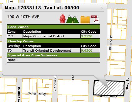
Zoom and Click on a Tax Lot

Tax Lot Boundaries Legend Eugene City Limits Legend Eugene Urban Growth Boundary Legend
Building Footprints Building footprints delineated using aerial photos or lidar data. This layer can be used for estimation of location of buildings on site but will not give exact measurements of distance to property lines and other structures. Footprint outlines and building locations are only approximate.
2 Foot Contour Lines Contour lines are generally accurate to ±1.5 feet. To be used for preliminary design only.

When submitting plans for new construction, if the elevation of the property changes more than 4 feet from one corner of the property to another, you will need to show 2 foot contours on your site plan. If you have questions regarding this requirement, please contact Intake staff at 541-682-5505.

Fire Hydrants Fire hydrant information and corresponding identification number are from the Eugene Water and Electric Board (EWEB). Eugene’s building division staff may require water flow information for your nearest hydrant for new buildings or additions. (This information is needed for residential structures exceeding 3600 square feet in total area. Commercial structures vary.) If needed, please submit a hydrant flow request to EWEB. Fire Hydrants Legend
Protection Overlay Water Quality (/WQ), Waterside Protection (/WP), Water Resource (/WR) and Wetland Buffer (/WB) zoning overlays derived from zoning overlays in the Eugene City Limits. Zoning regulates the land uses that are permitted. Zoning is also reviewed by the Oregon Land Conservation and Development Commission to insure it complies with standards.
Special Flood Hazard Area This layer identifies properties within the Special Flood Hazard Area (SFHA). Construction within the SFHA may trigger additional requirements. This layer does not include any map amendments. If you have questions regarding the special flood hazard area, contact Public Works staff at 541-682-8400.
  • A, AE and AO denote areas of 100 year flood. These areas make up the SFHA.
  • X5 denotes areas of 500 year flood.

For more information, see Flood Information.

Special Flood Hazard Areas Legend
Historic Sites Many sites in older neighborhoods have been surveyed to rate historic structures or conditions. Unless a property has been identified as a City Landmark or placed on the National Register, there will be no limitations on your proposed construction project. If you have questions, please contact Land Use staff at 541-682-8336. For detailed information about particular sites, see the Historic Sites Map. Historic Sites Legend
Plat Boundaries Plat boundaries are the exterior legal boundaries of plats and partitions. The boundaries include any public right of way dedication. To view a recorded plat, select a taxlot, then click on the folder to view all documents associated with a property.
City Wards City of Eugene City Council Ward boundaries. The Eugene City Council adjusts council ward boundaries every 10 years to accommodate population changes. Based on available 2010 US Census data, Eugene's population totaled 156,222 which means that each of the eight wards should have approximately 19,528 residents.
City Neighborhoods City-recognized neighborhood associations as described in their respective charters. The Neighborhood Services office maintains current charters for each neighborhood association. Each neighborhood is assigned a number code. If neighborhoods consolidate they get a new code and the old one is retired for historic purposes. If a neighborhood subdivides, a portion would retain the old code and a new code or codes would be assigned to the remaining portions.
House Numbers Site address house numbers for all addressable structures in the City. Select a tax lot to view a complete list of secondary addresses.
2008 Aerial Photographs 2008 6-inch per pixel color orthophotography.
2013 Aerial Photographs 2013 3-inch per pixel color orthophotography.
Lots over 1 Acre Taxlots with an area greater than 1 acre.

An erosion permit may be required based on the area of disturbance. If you have questions about the requirement for an erosion permit, please contact Erosion Prevention staff at 541-682-8498.

Erodible Soil Shown are soils classified as highly erodible (erodibility index of 8 or larger), as classified by the Natural Resources Conservation Service (NRCS), formerly the Soil Conservation Service.

An erosion permit may be required based on the area of disturbance. If you have questions about the requirement for an erosion permit, please contact Erosion Prevention staff at 541-682-8498.

Slope over 10% Derived from LIDAR (Laser Imaging Detection and Ranging) acro slope grid data comprised of areas of greater than 10% slope and greater than 400 square feet in area.

An erosion permit may be required based on the area of disturbance. If you have questions about the requirement for an erosion permit, please contact Erosion Prevention staff at 541-682-8498.

Direct Drain Lots Taxlot whose surface water drains directly into a ditch or water body. Such lots may require an erosion prevention permit to develop.

An erosion permit may be required based on the area of disturbance. If you have questions about the requirement for an erosion permit, please contact Erosion Prevention staff at 541-682-8498.

WEW Wetland Protected, restored and undesignated wetlands mapped by private consultants primarily in the West Eugene Wetlands Plan (WEWP) area. The WEWP is a Wetland Conservation Plan Inventory that has been adopted by the the City of Eugene and Lane County and approved by the Oregon Division of State Lands and the U.S. Army Corps of Engineers.

If your property has wetlands on site and you submit a construction permit application, the Oregon Division of State Lands will be notified of your application and may require additional protections on the site.

DEQ Cleanup Sites The State of Oregon Department of Environmental Quality (DEQ) had a cleanup permit or investigation at these sites as of March 2008. This information helps determine if an erosion permit for construction work is needed. For information regarding erosion permits, contact the Erosion Prevention staff at 541-682-8498.

Cleanup permits or investigations include:

  • Cleanup sites (ECSI)
  • Hazardous waste sites (HazWaste)
  • Leaking underground tanks (LUST)
  • Permitted water dischargers (WQSIS)
  • Solid waste sites (SWIFT)
  • Underground storage tanks (UST)

More detailed information for some sites is available from DEQ's Facility Profiler or DEQ databases for each program.

DEQ disclaimers:

  • "Display of a facility by the profiler does not necessarily indicate any current or past problem, violation, or hazardous condition. This site will present information in all sites stored in DEQ's databases. To find out more about a specific activity or location, contact DEQ, using the permit or identifier provided by the profiler."
  • "This product is for informational purposes, and may not be suitable for legal, engineering or surveying purposes. This information or data is provided with the understanding that conclusions drawn from such information are the responsibility of the user."
WQ Waterways Waterway segments affected by the Council-adopted Water Quality Overlay Zone. There are two types of WQ Waterways: those identified as "Tributary to 303(d) Waterways" and those identified as "Headwater Streams." This data was taken directly from the WQ Waterways Map adopted by the City Council. WQ Waterways Legend
WQ Management Areas Areas including and adjacent to WQ Waterways regulated by City Code Sections 9.4770 through 9.4790. This data was taken directly from the WQ Waterways Map adopted by the City Council.
WQ Setback Measure Line The setback measurement point used to determine the Water Quality Management Area. For "Tributaries to 303(d) Waterways", this is the top of high bank. For "Headwater Streams," it's the centerline of the stream. This data was taken directly from the WQ Waterways Map adopted by the City Council.
Soil Types Soil type as defined by Natural Resource Conservation Service. Soils Legend
Soil Shrink/Swell Capacity Sites that have a moderate or high shrink/swell potential as identified by Soil Survey of Lane County are shown. Construction in these areas requires a licensed design professional to evaluate the soils during excavation. If you have questions regarding this requirement, contact the Residential Plans Examiner at 541-682-5611. Soil Shrink/Swell Legend
EWEB Overhead Lines Applications for new construction that are in conflict with EWEB overhead lines will be referred to EWEB for follow-up. EWEB Overhead Lines Legend

EWEB Disclaimer

Geospatial data from EWEB is a schematic/cartographic representation of facilities in the field, and should be treated as such. Persons using this data will not rely upon it for the specific and definitive location of any facilities, property lines or other landmarks, but rather, will utilize the Oregon Utility Notification Center (1-800-332-2344), surveys and other independent sources to locate any facilities, property lines or landmarks.

Enter an address or tax lot and we'll mark it on the map.
Search Information
What is the ?
Construction Activity in Eugene

This resource is primarily used to inform Building and Permit Services staff and applicants regarding conditions on a particular site which may affect requirements for accepting and/or approving an application for construction.

If you have questions regarding this information and how it may affect your proposed construction project, please contact Building and Permit Services staff at 541-682-5505.

For comprehensive information regarding zoning, please refer to the Eugene Zoning Map.

For information regarding historic preservation, please refer to the Historic Sites Map.

Maps and GIS Disclaimer

The maps and data available for access from the City of Eugene are provided "as is" without warranty or any representation of accuracy, timeliness or completeness. The burden for determining accuracy, completeness, timeliness, merchantability and fitness for or the appropriateness for use rests solely on the user accessing this information. The City of Eugene makes no warranties, expressed or implied, as to the use of the maps and data available for access at this website. There are no implied warranties of merchantability or fitness for a particular purpose. The user acknowledges and accepts all inherent limitations of the maps and data, including the fact that the maps and data are dynamic and in a constant state of maintenance, correction and revision. Any maps and associated data for access do not represent a survey. No liability is assumed for the accuracy of the data delineated on any map, either expressed or implied.

Map Tips
To Pan the Map:
  • Left-click and drag with the mouse
  • Double-click the left mouse button.
  • Use the Arrow keys (← ↑ ↓ →)
To Zoom In or Out:
  • Use the zoom slider in the upper left hand corner of the map:
    Zoom slider
To Zoom In:
  • Scroll the mouse wheel forward
  • Use the + key
  • Press the Shift key, then Left-click and Drag the mouse:
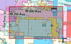
    Zoom in by dragging the mouse
To Zoom Out:
  • Scroll the mouse wheel backward
  • Use the - key
  • Press the Shift and Ctrl keys, then Left-click and Drag the mouse.
To See Property Details:
  • Search by address or tax lot number
  • Zoom in and click on the taxlot
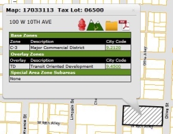
See property details
Use Property Detail Tools:
  • Hydrant buffer tool Draw 400' Fire Hydrant Buffer
  • Erosion factors tool Analyze Erosion Factors
  • Documents tool View Property Documents
  • tool View Property Report
Special Building Setbacks Special setbacks are specified for the purpose of perserving extra right of way (ROW) for future construction. Due to historical development patterns, many streets have public ROW widths that are less than needed to meet City safe and efficient circulation standards as specified in Chapter 9 of the City Code, Land Use. Special setbacks identify where ROWs may eventually extend for new construction setback purposes. Special Building Setbacks Legend
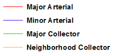
Street Classes Street classes represent streets classified as arterials and collectors. This data was adopted by the Eugene City Council effective August 2017. The data is updated as new arterials and collectors are identified by Public Works Transportation. Data is located and based on the City's surveyed centerline data and 2004 air photos. Street classifications are determined by the City's Public Works Transportation Engineer. This data is used for planning purposes. Street Classes Legend
Five Year Street Warranty Newly constructed streets and alleys are under warranty for 5 years after construction. Five Year Street Warranty Legend
Current Capital Projects These are capital projects that are scheduled for construction during the current calendar year. At the beginning of each year, engineering teams provide a list of proposed construction projects for the calendar year. These are added to this map. Once a project is completed, the project's status changes from current to past. It is then deleted from this map.

For more information, see the Eugene Current Projects map.
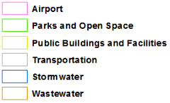
Current Capital Projects Legend
Future Capital Projects These projects that are proposed for contruction, but are not scheduled for construction during the current clendar year. Once a project's status changes, it is removed from this map and added to the Current Capital Projects map.

For more information, see the Eugene Future Projects map.
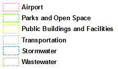
Future Capital Projects Legend
Soil Permeability Group This data is compiled from the Eugene Soils dataset. It is primarily used by City of Eugene land use review and permit staff. The data is based on national mapping standards so local data may be more accruate. Soil Permeability Group Legend
Depth to Groundwater Areas with depth to goundwater less than 6 feet. Depth to Groundwater Legend
Depth to Bedrock Areas with depth to bedrock less than 5 feet. Depth to Bedrock Legend
Elevation Over 500' Areas with elevation over 500 feet. Elevation Legend
Public Utility Easements Recorded public utility easements for wastewater and stormwater. Public Utility Easements Legend
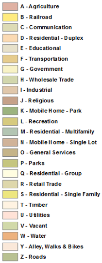
Land Use Generalized land use categories based on current land use data. This data is provided by Lane County, compiled from multiple sources. Land Use Legend
Error Icon
Information Icon
Question Icon
Warning Icon