City of Eugene
Eugene ArcGIS Maps
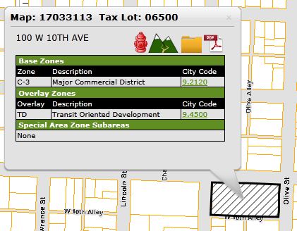
Use the Search TaborZoom and Click on a Tax Lot
When submitting plans for new construction, if the elevation of the property changes more than 4 feet from one corner of the property to another, you will need to show 2 foot contours on your site plan. If you have questions regarding this requirement, please contact Intake staff at 541-682-5505.
For more information, see Flood Information.
An erosion permit may be required based on the area of disturbance. If you have questions about the requirement for an erosion permit, please contact Erosion Prevention staff at 541-682-8498.
If your property has wetlands on site and you submit a construction permit application, the Oregon Division of State Lands will be notified of your application and may require additional protections on the site.
Cleanup permits or investigations include:
More detailed information for some sites is available from DEQ's Facility Profiler or DEQ databases for each program.
DEQ disclaimers:
EWEB Disclaimer
Geospatial data from EWEB is a schematic/cartographic representation of facilities in the field, and should be treated as such. Persons using this data will not rely upon it for the specific and definitive location of any facilities, property lines or other landmarks, but rather, will utilize the Oregon Utility Notification Center (1-800-332-2344), surveys and other independent sources to locate any facilities, property lines or landmarks.
Enter an address or tax lot and we'll mark it on the map.
This resource is primarily used to inform Building and Permit Services staff and applicants regarding conditions on a particular site which may affect requirements for accepting and/or approving an application for construction.
If you have questions regarding this information and how it may affect your proposed construction project, please contact Building and Permit Services staff at 541-682-5505.
For comprehensive information regarding zoning, please refer to the Eugene Zoning Map.
For information regarding historic preservation, please refer to the Historic Sites Map.
Maps and GIS Disclaimer
The maps and data available for access from the City of Eugene are provided "as is" without warranty or any representation of accuracy, timeliness or completeness. The burden for determining accuracy, completeness, timeliness, merchantability and fitness for or the appropriateness for use rests solely on the user accessing this information. The City of Eugene makes no warranties, expressed or implied, as to the use of the maps and data available for access at this website. There are no implied warranties of merchantability or fitness for a particular purpose. The user acknowledges and accepts all inherent limitations of the maps and data, including the fact that the maps and data are dynamic and in a constant state of maintenance, correction and revision. Any maps and associated data for access do not represent a survey. No liability is assumed for the accuracy of the data delineated on any map, either expressed or implied.
For more information, see the Eugene Current Projects map.
For more information, see the Eugene Future Projects map.